When we arrived in Buena Vista, it was just short of sunrise. We were treated with a beautiful pink sky as the sun approched the horizon. We found the parking area at the bottom of the trailhead with no problems, and parked the car. I had read about parking along the road going up the mountain and considered driving further but decided not to risk not being able to find a space. As several cars rumbled past and we walked on and on I realized the folly of my mistake. In all we hiked 14 miles and ascended close to a mile in elevation, which is cool, and didn't phase my pre-adolescent partner, but if I had it to do again, I would have shaved a few miles and a couple thousand feet of climb and parked up the road. Lesson learned.
The first half of the hike was all on the dirt road, before we missed our turn onto the trail that leads to the peak. After seeing almost no other hikers the turnoff seemed a funnel where everyone came together. Several of us missed the turn, but I expect I was the only one carrying a handheld GPS unit that should have clued me in. I had long since turned the sound off, as I tired of hearing it beep with every waypoint I had plugged into it, seeing as how there were 250 total plotted it was beeping every minute or so. Luckily another hiker was heading back down and informed us that he (and we) had missed the turnoff. I was looking for the steps as shown in the route description on 14ers.com and still didn't see it. At least I wasn't the only one.
Having made the turn we proceeded along a pleasant cow path cutting through a green field before getting to the rocky portion. I normally enjoy scrambling, but there was a sufficiently large enough field of talus that even I was getting tired of climbing over rocks. It didn't help that I crushed my middle finger between two rocks, and almost fell a dozen times. My normally cat-like balancing abilities were in tune enough to save me from any serious falls but failed me enough to make for a few exciting moments. Of course Sam didn't have any issues. I would blame his smaller size but since I'm not much larger I wouldn't have much of an argument.
While crossing the talus field I noticed large black spiders and their accompanying webs every few feet. I have a distaste for spiders that borders on phobia, so this was a bit disconcerting, but I was able to avoid them pretty well. I have found that if you don't focus on whatever causes you distress, it bothers you less. What do hundreds of spiders feed on at 13,000 ft? Lost hikers perhaps?
We hit the peak three and a half hours after starting. We took the obligatory pictures, took in the wonderful views, and started back down. We stopped at 10:30 to rest and get a bite to eat, then made our way down to the car without event. It was a good hike, and I'm glad I was able to keep up with my hiking partner the whole way.
Sam on the road we should have driven up. At least it was shady.
Sam definitely added to the cool factor of the group.
Nice views looking back
And along the trail
This is looking back where the cow path had turned into rock. It is only a half-mile to a mile from the road to here.
This shows the large field of rocks you must cross. We followed the trail up to the saddle then followed the ridge to the peak at center right of the picture. We often were without trail here and just picked our way through the rocks.
Sam looking cool The rocks looking rocky. This portion makes wearing boots preferable to cross-trainers like I had chosen.
This picture from the top shows a majority of the trail after it leaves the cow path just on the other side of the ridge.
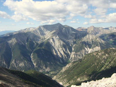
It's hard to believe you're seeing this with before your eyes and not in a magazine or painting.
Yes, I love Colorado.
We made it! Too bad you can't see more of the view in the background. Thanks Sam for letting me be the tallest. Don't worry, you can be the tallest next year. When you're a teenager.


